Discover our handpicked essentials for successful drone mapping - our "Top Picks". We've selected these products for their outstanding quality and effectiveness in the field. With our Amazon affiliation, ordering is a breeze, as Amazon will take care of delivery. Elevate your mapping experience today!
Our Top-Pick Drone for Mapping:
EVO II Pro 6K V3
Introducing the Autel Robotics EVO II Pro V3 – the ultimate solution for advanced mapping and 3D modeling. With its powerful 6K 1" CMOS Sensor, 9KM seamless video transmission, and an impressive 40-minute flight time, this drone delivers exceptional precision and efficiency for mapping.
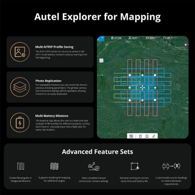
Engineered with professionals in mind, it’s compatible with Pix4D for streamlined data processing. Plus, the built-in mapping (mission planning) feature in the original app means no need for third-party software—simplifying your workflow while maximizing productivity.
Order now through our link below and elevate your mapping and modeling projects with the EVO II Pro Enterprise V3!
$2,099
Heavy Drone Landing Pad
2, 3, 5, or 8 Feet
Introducing the Hoodman Weighted Drone Landing Pad, crafted with robust materials to guarantee stability during takeoff and landing. Elevate your drone experience with this indispensable accessory.
Place your order directly through our Amazon associate link below!
Starts from $35
DroneDesk App
Ditch the spreadsheets, streamline your workflow, and fly smarter with Dronedesk.
Think all-in-one command center for your drone operations: client management, flight planning, compliance – it's got it all.
Free trial, check it out! ➡️
Starts from $13.5/month
FAA Pilot Safety Vest
Introducing our 9-Pocket FAA Licensed Drone Pilot Safety Vest. Designed for drone mapping pros, it's made with high-quality, lightweight material in neon yellow with orange accents. Stay organized with nine handy pockets for your gear. This vest meets safety standards, ensuring you're visible and compliant. Elevate your drone mapping game with this essential piece of gear.
Place your order directly through our Amazon associate link below!
$20
RTK GNSS Survey Equipment

Achieve unparalleled accuracy with the E1 RTK GNSS system, featuring 20 hours of endurance, 1408 channels, IMU integration, and a 5km UHF range. With 60° tilt capability and a handheld collector equipped with survey software, it's perfect for RTK surveying projects. Reliable, efficient, and built for professionals!
$2689
Bipod with Thumb Screw Head
Introducing the Aluminum Bipod featuring a Thumb Screw Head, designed for use with GPS Rover Poles or Prism Poles in Total Station Surveying Equipment. Experience smooth telescopic prism adjustments with this essential variation.
Place your order directly through our Amazon associate link below!
$99
More to Like
Our Mission
We bridge theory and practice in Geomatics, empowering both professionals and enthusiasts. Affordable access is our pledge, driving growth and progress for all.
We need your consent to load the translations
We use a third-party service to translate the website content that may collect data about your activity. Please review the details in the privacy policy and accept the service to view the translations.


